The Archipelago Sea is the largest archipelago in the world by the number of islands — around 50,000 of them, most no bigger than a small clearing of granite or a single birch clinging to salt-bleached stone.
By any measure of geography, Finland should not feel endless. It is a small, well-mapped northern country where roads are tidy, forests orderly, and distances finite.
Yet somewhere west of Turku, that sense of scale collapses. The land fractures into water and rock, and the water fractures into land again. Islands split into smaller islands; reefs turn into micro-continents. You enter a geography that seems to have been written not by cartographers but by a poet obsessed with repetition.
This is the Archipelago Sea — in Finnish Saaristomeri, in Swedish Skärgårdshavet — a quiet inland sea of the Baltic, nestled between the Gulf of Bothnia, the Gulf of Finland, and the Sea of Åland.
Neither tropical nor vast, the Archipelago Sea stands unique — numerically unparalleled, a world of fifty thousand fragments. The number sounds almost absurd. Fifty thousand islands: as if the mapmaker’s hand trembled and every tremor became new land. But here, absurdity is nature’s logic.
Table of Contents
A Geography Made of Fragments
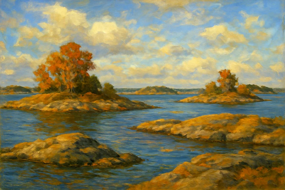
From above, the Archipelago Sea looks like broken glass frozen mid-explosion. Each shard is an island, each gap a strait. The distance from one to another is often so small that, at low tide, the sea seems to retreat in defeat.
Geologists will tell you this is the fingerprint of the Ice Age. The bedrock beneath southern Finland — ancient granite and gneiss more than a billion years old — was carved and scored by glaciers two kilometres thick.
When the ice melted some ten thousand years ago, the crust, suddenly relieved of its weight, began to rise again, a process known as post-glacial rebound. It still rises today, about five millimetres each year, slowly turning seabed into meadow, shoal into island, island into hill.
In other words, this archipelago is not a static thing. It is being written continuously, letter by letter, by time itself.
The Human Scale of an Infinite Landscape
The first time you take a ferry westward from Turku — Finland’s old capital and the mainland gateway to the islands — you sense how deceptive maps can be.
The first island comes quickly, then another, then another. The ferry docks, cars drive off, others roll on, and you realize you haven’t crossed an ocean; you’ve crossed a paragraph break.
Every few kilometres, another community flickers past: Nauvo (Nagu), Korppoo (Korpo), Houtskär (Houtskari). Each one is both remote and close.
Many are connected by bridges or causeways; others only by ferries that run with the patience of ritual. Postal workers, teachers, fishermen, and retirees move through this maritime web as if commuting through air.
Roughly 33,000 people live permanently among the islands, though the population triples in summer when city dwellers escape to their wooden cottages.
The rhythm of island life is determined less by clocks than by water: tides, ferry timetables, and the unpredictable moods of the Baltic wind.
Between Two Languages and a Thousand Stories
For centuries this region has been bilingual: Finnish and Swedish, sometimes mixing, sometimes not. Place names double like reflections — Parainen/Pargas, Nauvo/Nagu, Korppoo/Korpo — echoing the centuries when Finland belonged to the Kingdom of Sweden.
The bilingualism is not just linguistic; it’s cultural. The Swedish-speaking islanders of the Archipelago Sea maintain distinct traditions: wooden boat festivals, midsummer bonfires lit on rock ledges, and the calm, dry humour that comes from generations of living at the mercy of wind and weather.
Yet Finnish and Swedish life here intertwine easily, unified by something older than either language — the water itself.
A Labyrinth of Life
Ecologically, this mosaic of rock and sea is a cradle of diversity. The Archipelago National Park, established in 1983, protects much of the outer islands — a world of seals, eider ducks, and sea eagles. Beneath the surface, meadows of seagrass ripple in the brackish water, sheltering herring and perch.
The Baltic is a fragile sea, neither truly saltwater nor freshwater. Rivers from the north dilute it; the narrow Danish straits limit the inflow of ocean salt. The result is a unique gradient — an ecosystem balanced precariously between two worlds.
Climate change and nutrient run-off threaten that balance, turning some bays into algae-green bowls in summer. But the remoteness of many islands has spared them from the worst excesses of human interference.
A few dozen of these islands are uninhabited bird sanctuaries; others hold cottages, harbours, or century-old pilot houses still guiding ships through narrow passages. On some, the only trace of human life is a rusting anchor or a half-buried rope, reminders that even solitude leaves evidence.
Navigation: The Art of Not Getting Lost
Before GPS, sailors here navigated by instinct and memory. Each channel had its rhythm: a crooked birch on one island marking the next turn, a specific rock that appeared only when the tide fell. Even now, digital maps are secondary to local knowledge.
The sea changes constantly. Channels shift. Sandbanks rise. In winter, the water freezes solid enough to drive a car across, then thaws again into mirror-smooth silence. Many locals own both a boat and an ice-sled, adjusting to the season rather than resisting it.
To an outsider, the labyrinth can feel endless. To those born here, it’s a neighbourhood — one defined by distances measured not in kilometres but in crossings.
The Ring Road of Islands
There is, improbably, a road through this maze: the Archipelago Trail (Saariston Rengastie), a circular route of bridges, ferries, and narrow asphalt that connects the main inhabited islands.
Cyclists from across Europe come each summer to trace its 250 kilometres, pedalling from one ferry to the next like a slow-moving flotilla.
The trail embodies the spirit of the archipelago: motion without haste, isolation without loneliness. Each ferry is a pause, a floating bridge that gives travellers time to stare at the horizon and wonder how so much space can fit into so little distance.
A Culture Shaped by Water
In the Archipelago Sea, even the language of everyday life bends toward the maritime. People speak of the sea not as scenery but as neighbour, sometimes adversary, always companion. Boats are named like relatives. Weather forecasts are discussed with the intimacy others reserve for gossip.
Every midsummer, bonfires blaze on dozens of islands at once — a chain of flames visible for miles across the darkening water. It’s a ritual older than electricity, linking communities by light. For a moment, the sea seems stitched together.
Island culture has always been self-reliant. Before bridges and modern ferries, islanders built schools, post offices, and small shops that could function through long winters when ice made travel impossible.
Today, many of those same buildings serve new lives — as artist residencies, summer cafés, or marine research stations. The balance between tradition and adaptation feels effortless, though it is anything but.
A Frontier Between Stillness and Change
Standing on an outer skerry at dusk, you feel the paradox that defines this place. Everything seems immovable — granite, pine, the faint smell of salt and smoke. Yet the horizon is alive with motion: ferries sliding between channels, clouds shifting, the steady rise of the land itself.
Geographers note that the Archipelago Sea is literally growing — new islands slowly emerging each decade as the earth rebounds from its glacial past. It is one of the few places on the planet where the land is winning against the sea.
That subtle expansion makes the region an open-air laboratory for scientists studying climate resilience. While many coastlines erode, this one regenerates.
But it also reminds locals that permanence is an illusion. Islands may rise, but so do temperatures, and ecosystems can tilt out of balance faster than geology can correct them.
The Meaning of “Largest”
Calling the Archipelago Sea “the world’s largest archipelago” invites argument. Estimates vary depending on how “island” is defined — whether it’s a vegetated skerry or a bare rock that surfaces only at low tide — but by most geographic counts, the Archipelago Sea contains more individual landforms than anywhere else on Earth.
Indonesia, Canada, the Philippines — all could claim the title by other measures: land area, population, cultural reach. But if the criterion is the number of islands, Finland’s quiet maze wins.
What that title means, though, depends on how you see it. To some, it’s a curiosity — a line in a trivia book. To others, it’s proof that magnitude isn’t always loud.
Here, the vastness hides in the miniature: in the way a patch of moss crowns a rock no wider than a door, or a fishing hut holds an entire family history within twenty square metres.
The Archipelago Sea is immense precisely because it resists simplification. You can measure its islands, but not its intimacy.
The Last Light
On a summer night, when the sun refuses to set and the horizon glows like the inside of a shell, the sea lies still enough to mirror the world perfectly. You could almost believe there is no border between above and below, between island and reflection.
Somewhere in that quiet symmetry lies the secret of the Archipelago Sea: that its greatness doesn’t come from spectacle but from accumulation — of islands, yes, but also of stories, lives, and silences.
Fifty thousand islands, and not one of them identical.
Fifty thousand ways to understand that the world, even in its smallest fragments, is inexhaustible.